|
Seismic Hazard Maps for Specified Seismic Source Faults |
Probabilistic Seismic Hazard Maps |
| Definition |
"Seismic Hazard Maps for
Specified Seismic Source Faults" pay attention to specific seismic source faults and indicate, the strong shaking of the surrounding areas when an earthquake occurs.
|
"Probabilistic Seismic Hazard
Maps show the probability for a fixed time period and
intensity, and intensity for a fixed time period and
probability. These parameters are estimated by treating the occurrence of various
earthquakes and the strength of shaking using probabilistic
theory.
|
| Example |
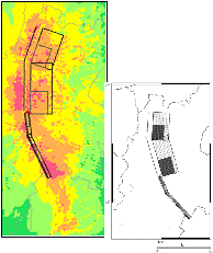
Seismic intensity on the ground surface (left figure) of a
rupture case (right figure) in the earthquake of the
Itoigawa-Shizuoka-kozosen fault zone.
|
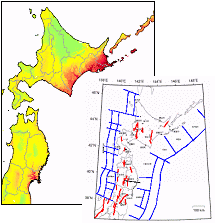
Distribution map of probability of ground motions equal to or larger than seismic intensity 6 Lower, occurring with in 30 years from the present.
|
| Major characteristics |
- Assume scenarios of a specific earthquake
- The map is prepared per scenario
- Able to provide evaluation of seismic ground motion considering seismic source, propagation, and site characteristics.
- Provides the waveform besides the map.
|
- Modeling all earthquakes according to its type using probabilistic theory.
- Seismic ground motion is calculated using an empirical formula (attenuation relation).
|